
Greece is moving forward with the implementation of the National Spatial Strategy for the Marine Area (NSSMA), which defines and maps the country’s Maritime Spatial Planning (MSP). This marks a strategic milestone, as it establishes—for the first time—a set of rules for the organization of marine space, integrating environmental protection requirements with sustainable development goals.
The Ministers of Foreign Affairs, George Gerapetritis, and of Environment and Energy, Stavros Papastavrou, emphasize that the MSP serves as the foundation for the development of the blue and circular economy, determining the scope of permitted human activities across all maritime zones of the country, with full respect for the natural environment.
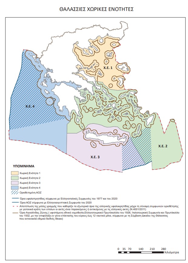
For the first time, the official delineation of Greece’s continental shelf boundaries is reflected in a European Union document, fully clarifying the country’s and its islands’ maritime entitlements. The NSSMA incorporates a wide range of often conflicting parameters—social, economic, environmental, and energy-related—with the aim of strengthening the climate resilience of marine ecosystems, protecting cultural heritage, and enhancing marine transport and aquaculture.
The MSP was developed following an extensive consultation process with relevant institutions and local authorities. The plan addresses the interaction between land-based and maritime activities across four spatial units that align with the administrative divisions of the country’s Regions. To date, 12 of the 13 regional zones have been completed, with the final one currently under development.
This strategic planning framework ensures the sustainable use of Greece’s marine resources, while fully aligning with EU strategies for marine protection, such as the European Green Deal and the EU Maritime Security Strategy. Greece’s maritime zones are defined in accordance with international delimitation agreements, including the Greece–Italy and Greece–Egypt agreements signed in 2020.
The Country’s Conviction by the European Court of Justice
This pertains to the implementation of Directive 2014/89/EU on Maritime Spatial Planning, with Greece paying the price for its "non-compliance" through a conviction by the European Court of Justice, following delays in its application. The conviction underscores the need for swift and comprehensive development of the planning process, despite the challenges posed by geopolitical and geographical conditions.
The text of the ruling highlighted the country’s delays and refuted the arguments concerning the reasons for the delay, which included the complexity of the institutional framework, geographical particularities, the extensive coastline, the country's insular nature, the geopolitical conditions in the Eastern Mediterranean, and the bilateral agreement on the delineation of the Exclusive Economic Zone (EEZ) with Egypt.
The ruling stated that Member States cannot invoke internal difficulties, their geographical characteristics, objective weaknesses, or force majeure to justify their failure to meet their obligations. It emphasized that maritime spatial planning does not affect the sovereignty or jurisdiction of Member States over their maritime waters, is not linked to the process of delineating maritime zones, and cannot be contingent on the cooperation of a third state.
Turkey’s Response
The unilateral actions and claims of Greece regarding maritime spatial planning will have no legal consequences for Ankara, the Turkish Ministry of Foreign Affairs stated on Wednesday following Greece's announcement regarding its maritime spatial planning within the EU framework.
"Some of the areas outlined in the 'Maritime Spatial Planning (MSP)' document announced by Greece under EU legislation infringe on Turkey's maritime jurisdiction in both the Aegean Sea and the Eastern Mediterranean," the Ministry stated.
At the same time, Turkey announced that it would submit its own maps to UNESCO and the United Nations.
Turkey’s recent reaction to the new Maritime Spatial Planning, claiming that certain areas infringe upon its maritime zones, is part of the broader geopolitical context of the Eastern Mediterranean. However, Greece emphasizes that the planning does not affect the sovereignty rights of states and is not dependent on external agreements, focusing instead on the protection of ecosystems and aligning with the European strategy.


