The primary objective of the STP Thira is to significantly restrict unplanned construction, which is closely tied to the preservation of vital resources within the Municipality, including agricultural land, the natural environment, archaeological sites, and traditional settlements. In most areas, as in Mykonos, the permissible building area is limited to 8 acres for residential use and 40 square meters for tourist facilities. Additionally, there are designated areas where construction is entirely prohibited.
The following recommendations are specifically outlined:
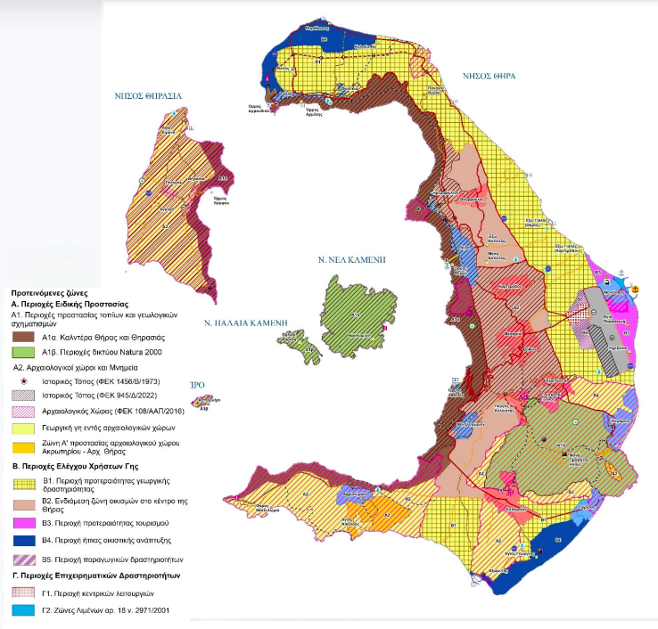
- Caldera Protection Zones: A ban on the construction of new buildings within these areas.
- Archaeological Sites: These sites have been updated in collaboration with the Ministry of Defense (2016), with Zone A (absolute protection) applied to Akrotiri and Ancient Thira.
- Tourism-Leisure Zone: Located in Monolithos, this zone supports the development of the new port.
- Residential Development Zones: Two areas are designated for controlled, low-impact off-plan residential development—one in Perissa and another along the northern and northwestern coasts of Thira.
- Productive Activity Zone: Positioned west of Thira Airport, with a central operations zone planned along both sides of the main road leading to the airport.
- Protection Zone for Settlements: A single protection zone is designated for the central area of Thira, where there is significant pressure for construction.
- Agricultural Priority Areas: The remaining land, which constitutes the majority of Thira's total area, is preserved as priority zones for agricultural activity.
The new urban planning initiative aims to create favorable conditions for the development of both the primary and secondary sectors—areas in which the island currently lags—while also diversifying the tourism sector. This will be achieved by promoting alternative forms of tourism and facilitating a more balanced distribution of tourist flows both spatially and temporally.
To achieve this dual objective of protection and sustainable development, specific zones for designated activities are proposed, accompanied by appropriate urban planning conditions and restrictions. These measures will enable the implementation of policies that limit or prohibit new activities outside of these designated zones.
Over time, this approach will foster a more balanced spatial organization and a broader economic base, laying the foundation for the future development of Thira as a premier tourist destination. Additionally, it will serve as a model for the successful integration of protection policies in urban planning.
Development improvements
The proposals outlined in the pre-qualified STP Thiras present a strategic approach to the island’s spatial development. The landscape is divided into distinct local units, each characterized by unique morphological features and physiognomy, designed to serve as hubs for the development of alternative forms of tourism and agricultural activities. Three designated viticultural regions, with the potential to achieve Protected Designation of Origin (PDO) status, are identified, alongside an additional agricultural zone on the eastern coast of Thira, designated for agricultural production and compatible uses.
Tourism and leisure zones are planned for specific coastal areas, including established tourist destinations such as Perissa and Monolithos, as well as areas earmarked for future development, particularly to the north of Oia.
The island’s airport, serving as a primary entry point, will be further supported by the planned new passenger and commercial port in neighboring Monolithos. These major transportation infrastructures will enable the sustainable development of a productive activities zone, encompassing logistics and commercial operations, and will be directly connected to the island’s key transportation networks. This integrated approach ensures the long-term viability of Thira as a balanced, high-level tourist destination while promoting sustainable economic growth.
Settlements: bordering- safety-expansions
To enhance the protection and preservation of the settlements, as well as to improve the overall quality of life, the proposed STP recommends the demarcation of four traditional settlements—Tholos, Finikia, Imerovigli, and pre-23 settlements—that have not yet been officially designated. Additionally, it suggests the re-approval of the boundaries for the 18 existing demarcated settlements. For all these settlements (except for the demarcated settlement of Perissa), zoning plans are proposed in alignment with the provisions of the PD plan, which was provided to the researchers by the Ministry of the Interior.
Furthermore, for the settlements that already have a Town Planning Study—Thira (Government Gazette 852/D/1991) and Perissa (Government Gazette 428/D/1993)—the land use plans will be updated in accordance with PD 59/2018.
In response to emerging needs identified in the capacity assessment for the year 2040, and in line with the proposed policies of the PES, extensions are suggested for the settlements of Oia, Fira, and the newly demarcated settlements of Tholos and Imerovigli.
Starting today, Friday, November 15, and continuing for a period of five (calendar) days, interested citizens and organizations are invited to submit their comments and proposals regarding the STP of Thira via the participation platform established by the General Secretariat for Spatial Planning and Urban Environment of the Ministry of Environment and Energy. The platform can be accessed at: https://polsxedia.ypen.gov.gr.

